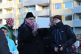
In October 2014 the citizens in Koskela neighborhood of Helsinki were introduced to construction plans in the area using a novel way enhanced by augmented reality. Through VTT’s augmented reality application people could see how the new buildings in the hospital area would look like in their real environment. The EIT ICT Labs pilot was done in collaboration with Helsinki City Planning department, VTT and Forum Virium Helsinki.
Four different construction plans have been made for the Koskela hospital and laundromat site. The plans were evaluated on a chilly walking tour around the area, and in a group discussion following the walk. Anyone interested in the topic was able to join these events.
Application helps visualize the location and height differences of buildings
There were about 20 people participating in the walking tour exploring the plans with the augmented reality application. The application is used with a tablet or other smart devices with camera. Most of the users perceived the application easy to use, the application functioned well technically and many thought that the urban augmentation helped them to better visualize the plans. The application added a new dimension to the traditional ways of visualizing, but some of the users felt that the traditional pictures would have been enough.
Other users wished for more accurate and detailed designs to be included in the application. For now the designs were too rough to evaluate. The application illustrated a good overall view of the area and helped the users to visualize the use of the space, location of the buildings and the height differences between the buildings. Users also hoped that the application could be used on a bigger screen or that they could download the application for their smartphones so that anyone interested could explore the plans on their own.
“The augmented reality helped to visualize the used space and proportions of the city space. The application has its limitations and it is not meant for every situation. For example the trees around Koskela area limited the use of application in this pilot”, says Antti Varkemaa, project manager from the Helsinki City Planning Department.
"The experiences from this pilot were inspiring. Urban augmentation has a lot of potential from urban development to opening new possibilites to go beyond the traditional wayfinding and tourist services. For next year we plan to offer citizens apps that will enable to explore the future plans and history of the city through augmented reality", explains Pekka Koponen, Development Director from Forum Virium Helsinki.
More information:
Kaisa Spilling, Forum Virium
Charles Woodward, VTT